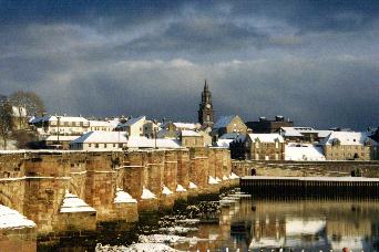
Here is a picture of the
town's 'Old Bridge' as
seen from the Tweedmouth
side of the River Tweed.
The Town Hall (Guildhall)
stands proudly in background
Photograph by Colin Thompson
| Holy Island |
| Newton & Craster |
| Norham |
| Seahouses |
| Warkworth |
| Wooler |
Highly picturesque, Berwick is the northernmost town in England, Steeped in history, and fascinating to explore on foot. It is built mainly of stone in grey to pinkish brown. The harbour has swans. The town is piled upon a peninsula at the mouth of the Tweed and it faces the river, rather than the sea. Three great bridges connect it with Tweedmouth on the south side of the estuary: the low stone bridge with 15 arches of varying height and width, completed in 1634; the 1928 concrete span known as the Royal Tweed which has just had a recent facelift and the railway’s Royal Border with its 28 soaring arches, completed in 1850. The town is an entrancing sight from the Tweedmouth bank or the railway bridge. Tweedmouth keeps a feast on the Sunday after 18th July honouring St Boisil, a Saxon holy Man to whom the present St Bartholomew’s Church (1783) was dedicated at its founding in 1143. Today the ‘salmon queen’s’ coronation opens a week of events
|
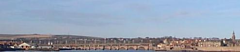
Here is a picture of the
Photograph by Colin Thompson |
Berwick’s well-worn appearance seems to suit its historical role as a buffer town. It was an important trading centre and international port. The town captured or sacked 13 times before 1482. when it was finally made English. Until 1746 Berwick had a special status as a free borough and was mentioned separately in Acts of Parliament. (So far as records had shown, it was still at war with Russia in the Crimea, having been specifically listed as declaring hostilities in 1854 and having been left out of the 1856 Peace Treaty.)
Berwick was part of the ransom paid by the captured William the Lion of Scotland to Henry II in 1147. It was sold to the Scots by Richard I to get money for his Crusade. I t was destroyed in 1216 by King John in person. When William Wallace (Braveheart) was executed in 1305 in London, one quarter of him was displayed here as a warning to other rebels. I can only assume that the Wallace green was named after him The Countess of Buchan, who had crowned Robert Bruce King of Scotland, was caged for six years in the castle yard from1306.
Berwick has had two sets of protecting walls and the remains of the later ones give visitors their most interesting circuit of the town. The first walls were completed in the reign of Edward II and little is left of them. The town was then fortified by Elizabeth I, starting in 1558, on the new Italian design with great emphasis on effective use of artillery. The walls cost a staggering £128,648 and were the most expensive undertaking of the Elizabethan period. The Berwick walls are the only example of this style in Britain and among the earliest of the type in Europe. Three of the projecting bastions, shaped like flat arrowheads, remain. Cowport is the only surviving original gate. The high ramparts of earth and stone include Meg’s Mount with its superb view of the town, the river and the sea
Berwick upon Tweed
The Historical Walled Town
 |